

|
|
|
#47
 10-03-2018, 03:18 PM
|
|||
|
|||
|
Sorry to dig up an old thread, but looking for some route guidance. I'm looking to head up to here in the next few weeks and was trying to put together a decent loop of 40 to 50 miles or so, the less pavement the better! Since I'm coming from the south, I was thinking about parking around Walden at the bottom of the rail Trail, take that north for a bit, and then cut West to the Awosting entrance, climb up to the lake, then take some roads North/East, and then end with the Walkill trail back south again. My first issue is getting to Lake Awosting. On the map it looks like some of the trails are hiking only? I'll be on 2.35" 'road' tires, so not too worried by trails, but don't want to get in any trouble! Any advice would be appreciated.
Mark Edit: Here's what I came up with so far. Feel free to critique: https://ridewithgps.com/routes/28720200 Last edited by BikeNY; 10-03-2018 at 03:38 PM. 
|
|
#48
10-03-2018, 03:40 PM
|
|||
|
|||
|
Hi,
Take a look at this route. Did it a few weeks ago. Nice mix of terrain. Once you exit the dirt at Traps bridge nice descent to end the ride. https://ridewithgps.com/routes/28321464
|
|
#49
10-03-2018, 05:46 PM
|
|||
|
|||
|
Quote:
Trails can be pretty gnarly here, even some of the double track on the Minnewaska side...but, double track is definitely more friendly for your bike choice probably. There will almost 100% be a ranger at the Trapps bridge (route 44/55) to collect your day use fee. I frequent the "Spring Farm" end near High Falls, so that is what I will comment on. On your current route for example, right around mile 36/37, I think that is a hiking trail only (pretty sure..check into that). Instead, you'll want to take "Clearwater Road" to Old Canaan Road to the Wallkill Valley Rail Trail. It's marked to a certain extent, but once you're pointed downhill, they (Mohonk) have not marked it at all. Also, the spots right before miles 38 and 39 are pretty swampy, so just be ready for that. We've had a TON of rain lately. Actually, swamp at Mile 38 is a legit swamp now that I think about it. If you push through the swamp though, I'd suggest you modify the route and bang a left/north onto the trail at Mile 38; the "Larson Loop". Bikes allowed, Great technical and swoopy trail with great views, and it dumps you just uphill of Rosendale. Go to the Alternative Baker or the Big Cheese for a treat for the pedal home. Last edited by YoKev; 10-04-2018 at 05:59 AM.
|
|
#50
10-04-2018, 08:42 AM
|
|||
|
|||
|
Quote:
Also, the last section up to the lake around miles 12/13. I couldn't find anything called Larson Loop, but I changed to route to take a trail North, I think that's what you were talking about. Side trip into Rosendale as well. I shortened the loop by starting/finishing in Walkill instead, any suggestions for a safe place to park in Walkill? I'm OK paying the day use fee if needed. New route: https://ridewithgps.com/routes/28720200
|
|
#51
10-04-2018, 09:04 AM
|
||||
|
||||
|
check out this thread we did last year right around this time also for some ideas.
when are you riding? if i'm in town i'd love to join you, i love it up there. https://forums.thepaceline.net/showt...ght=minnewaska
__________________
http://less-than-epic.blogspot.com/
|
|
#52
10-04-2018, 09:11 AM
|
|||
|
|||
|
I can't comment on the Mile 12/13 question, but you did correctly reroute to my suggestion
 Just remember, where Clearwater changes to "Old Canon", that is a steep downhill to the lowland swamp. You will see a double track going through it though. You wont get lost, but you will get wet and very muddy. 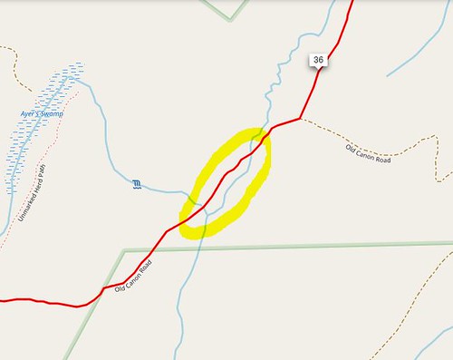 Enjoy the ride!
|
|
#53
10-04-2018, 09:15 AM
|
||||
|
||||
|
the other thing to bear in mind, and of course i have no idea of your fitness level or experience on gravel - so ignore if this is NA or obvious:
riding gravel up there always takes longer than i thought it would. for example, a 60 mile road ride with moderate hills is 4 and a half hours or so. 60 miles of lots of gravel, with the slower speeds, stopping for pictures, enjoying the scenery, etc - could easily be deep into 5 hour territory. just something to think about.
__________________
http://less-than-epic.blogspot.com/
|
|
#54
10-04-2018, 02:11 PM
|
|||
|
|||
|
Quote:
Quote:
Quote:
|
 |
|
|


 Linear Mode

